
Page Contents
Enhanced Erickson Map of Riderwood
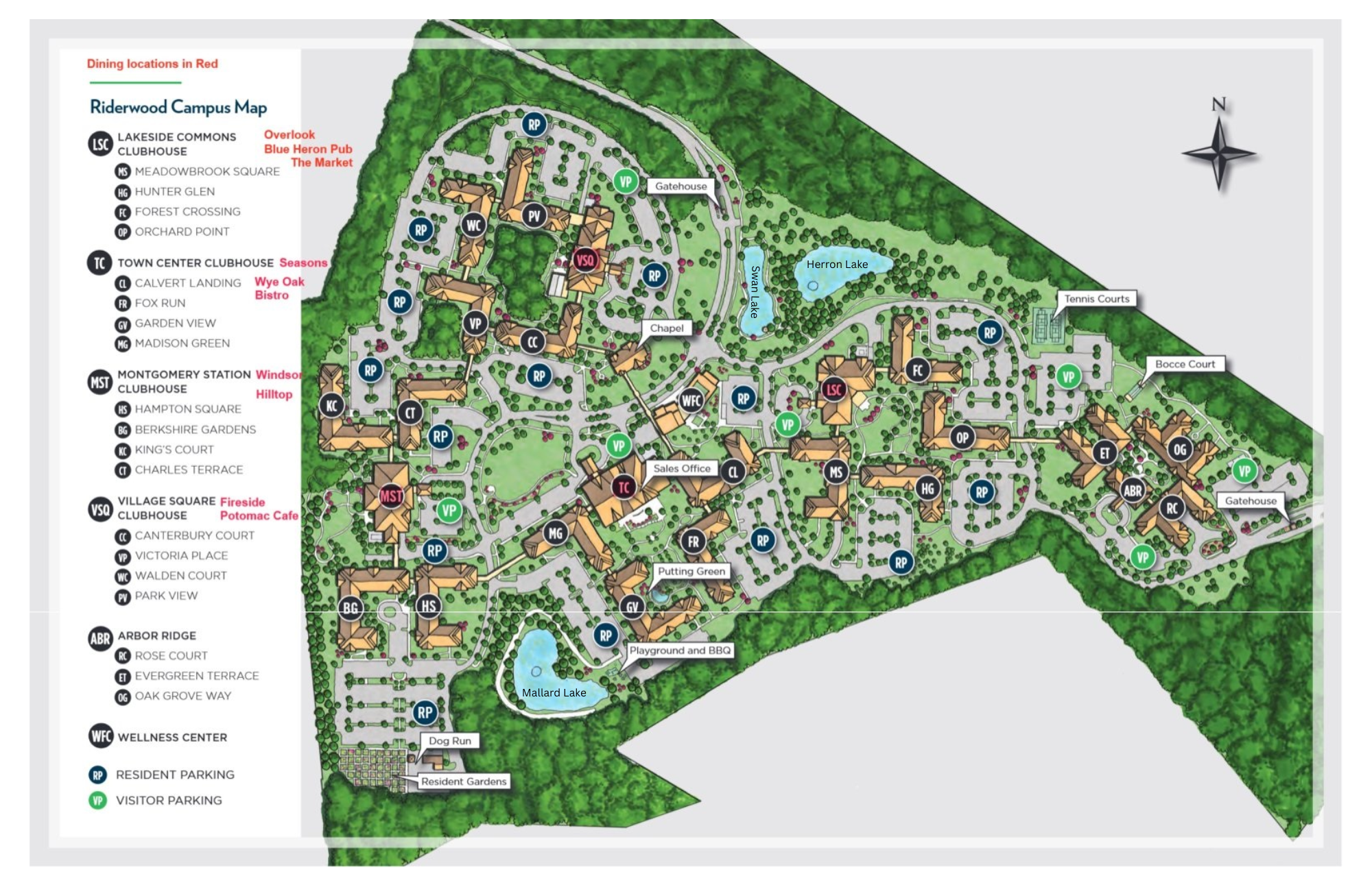
Erickson Senior Living map showing neighborhoods, buildings, PLUS restaurants, ponds , etc. Click on Image for full size version.
Facility Locator

Click here to download/view a pdf version of the above listing.
Google Map of Riderwood
Click on “Directions” or “View large map” above to go to Google maps.
Schematic – Elevators, Bus Stops, Etc.
Find locations for local bus stops, elevators, elevation
(floor level) for links between buildings. Click on map for full size image.
For a PDF version of this map click HERE.
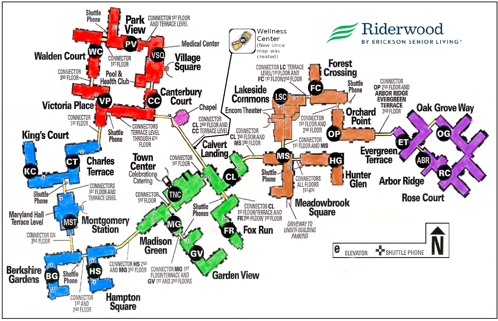
“Conceptual” Map

This map, derived from the “Schematic” map, above, was created to show how “club houses” and residential buildings are grouped; it was simplified for easier viewing. Click map for full size version.
3-D Aerial View

- Aerial 3-D image of Riderwood Village from Google Earth Pro.
- Click on image for full size view
- Google Earth Pro enables neat options to “play” with a satellite view of Riderwood – rotate, zoom, change perspective; wait a moment for the map to load. View striking images of Riderwood Village. Works best on desktop computers.
Aerial View Showing County Line

Click on photo for full size image.
Where’s the Line Drawn?

The position of the Prince George’s County – Montgomery County line is labeled on the window sill in the link between the Chapel and Village Square community. (Updated 6/2/22.)
Walking Map – Nearby Park

Click image for full size map.
Driving to Riderwood

Riderwood is conveniently located in Silver Spring, about a mile from the intersection of
Cherry Hill Road and Route 29 (Columbia Pike).
- From Montgomery County region: Take Randolph Road east. (When you cross Route 29, Randolph Road becomes Cherry Hill Road. At the third traffic light on Cherry Hill Road, make a left on Plum Orchard Drive. (The Orchard Center Shopping Center will be to the right.) The end of Plum Orchard Drive leads directly into the main entrance to Riderwood.
- From College Park: Take Route 1 North. Turn left onto Cherry Hill Road. Go to the third traffic light. Turn right onto Plum Orchard Drive. Continue onto the main drive into Riderwood.
- From Silver Spring (to the south: Take Colesville Road (Route 29) north. Make a right onto Cherry Hill Road. Follow above directions onto the main entrance drive
- From Interstate 95 (north of the Beltway): Take Exit 29-B, Route 212 / Powder Mill Road and head west 1.3 mi toward Calverton. Turn right onto Cherry Hill Road, and drive 0.8 mile. Turn right onto Gracefield Road. At the stop sign, turn right onto the main entrance drive and proceed to the main gate.
- From the East, South East and I-95, a GPS device may direct visitors to the “back gate” / Gate 2.
- Upon arrival at a gatehouse, advise the attendant of the name, bldg., for the resident bldg. to be visited. Ask for directions and/or refer to above maps. The attendant will issue a visitor parking pass
Click here from a 1 page pdf printable version of these driving instructions.
Arbor Ridge
PDF Floor Plan map of Arbor Ridge prepared by the Arbor Ridge office manager along with a list of the Arbor Ridge neighborhoods by floor and by level of care. Click the image below to see all 3 pages.

Historical Maps/Land Title
Understanding and Finding Addresses at Riderwood
Last updated 3/12/2024 RTT